Angus? It’s not just a good name for a Highland cow (actually, bull). It’s a really interesting chunk of Scotland that you might have overlooked.

Answering the question about where is Angus is easy: it’s that east-side chunk of Scotland just above the central belt that is partly in the Highlands yet also about as typically east coast Lowland as it can get.
An even shorter answer would be: Angus is often in the middle of a Scottish journey to somewhere else.


Nope, no arguing with geography. That’s the trouble with half-way places. They generate that mental note to ‘must stop off one day’ or a faint realisation that ‘gosh, this is nice – a pity we didn’t have more time’.
That’s always how Angus has struck me, anyway – and I’ve been on Scottish journeys, between north and south, all my days.
(Pictured: Arbroath Abbey.)
.
Easy access to a major Scottish city, easy access to the southern portion of the Cairngorms National Park; then add a selection of not unattractive wee towns plus a peerless coastline and it’s beginning to sound like a nice mix, don’t you think?
The former county of Angus is one of Scotland’s ‘unitary authorities’. Its residents mostly look to neighbouring Dundee for a city fix and they also have the advantage of disappearing up the Angus Glens if they want to ‘get away from it all’
(Pictured: high summer in Glen Prosen.)

And another thing. Angus has lots of potatoes. And strawberries. It’s altogether fertile and veggiefalarious. Then there’s seafood. You can’t move around downtown Arbroath without falling into a fish shop. You can even buy scallops on a Sunday down by the harbour. And we’ll get to Arbroath smokies in a minute (or, at least, further down the page).
Where is Angus? Not near Skye anyway…
So, why won’t you stop in Angus? Oh, wait, I know, you’re drawn to the royal connections in the valley of the River Dee, in Aberdeenshire to the north. So you’re cruising up the A90 – it’s an easy dual-carriageway anyway, that goes right through Angus.
If you really, really think you’d like Balmoral Castle, you can visit it on a day trip from an Angus base. (Oh, and if you read the things to avoid in Scotland page, then you’ll find find some reasons not to…!)
Hornswoggled by marketing…
However, it’s even more likely that you’ve been so hornswoggled by the marketing of the isle of Skye that you’re away to the west. Aye, you’ll be on the roadwork-smitten and half-clogged A9 en route for bustling Inverness or wet and bedraggled Fort William.
The Road to the Isles has once again trumped the Road to the Smokie (which I invented just now.)
Three parts of Angus
Consider Angus in three parts: the coast, the middle valley and the hills.
Here’s a quick skim through these components.
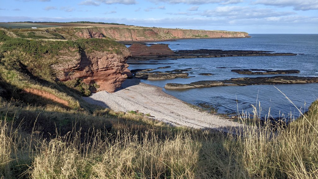
The coast is pretty spectacular and unspoilt. If you’d like to see (and I quote) ‘reticulate weathering of Downtonian sandstone’ then fill your boots. Serious geology is laid bare hereabouts.
(Pictured: Seaton Cliffs.)
On the other hand, if you’d just like some coastal walking with cliffs and coves, plus nice beaches, then you’ll love what’s on offer, and all signposted and explained by helpful info boards in many places.
Take Lunan Bay, for example. Between the towns of Arbroath and Montrose this picturesque place is well-resourced with a proper carpark and even a café behind the dunes. A long stretch of dazzling sands, you can see why it’s popular.

Overlooking where the Lunan Water reaches the sea and splits the beach in two you’ll find the ancient ruin of Red Castle.
‘Ancient’ here means extraordinarily old – part of the outer walls may be 12th century. It’s pretty ruinous too – stand well back! The headland was originally built on to protect the coast from Viking raids. Yes, it’s really that old hereabouts.
Another Angus clifftop delight

Just one more example of a popular coastal walk is the well-signposted clifftop path that links the town of Arbroath with the village of Auchmithie.
The path is safe and secure though the verticals are unnerving, should you stray… Actually, that’s a pompous way of saying ‘take care, will ya?’
This especially applies if you are intent on getting some pictures of a kittiwake colony you’ll notice on the way.
En route, waves and wind have sculpted many curious coastal features into the red sandstone: the Deil’s Heid, the Needle’s Ee, Meg’s Craig and others.
Strathmore – the Big Valley

The middle section is called Strathmore, from the Gaelic meaning the big wide valley. This area runs north-east/south-west with the frowning Highland hills above and some gentler slopes below, between valley and coast.
As well as being productive – including the most northerly asparagus farm in Scotland – there are fine woodlands and a cosy, weel-happit (Scots: well-wrapped up) feel about the area.
The presence of the Picts
It’s here, scattered in Strathmore, that you can encounter the mysterious people that the Romans named Picts – literally, the painted ones.
They left no written records but instead a pictorial mystery – sculpted symbol stones whose meanings are still unknown to us (and liable to remain that way until time-travel is invented).


In kirkyard or roadside they stand, a few in their original positions. They have been there since the Dark Ages. Z-rod, mirror and comb, serpent and other repeated symbols are found the length of Angus and beyond.
Tiny, rural Aberlemno is a good place to start. Puzzle over the serpent by the roadside; try to interpret the battle scene in the kirkyard. The stones have great presence. Catch them in a slanting sun, the better to pick out the detail…

The Highland Boundary Fault
Then – the third part of Angus – there are the big hills beyond the Highland Boundary Fault. What’s the HBF? Oh, that’s where geologically speaking, the real Highlands start. HBF and Strathmore lie in parallel.

As you whizz north, through Angus by the dual carriageway A90, the line of hills to the north look impenetrable. But – and this is such an attractive feature – long and mostly motorable glens run far into the National Park.
And where the drivable road stops, ancient, historic rights-of-way continue the journey up to the rolling plateau-lands of the Southern Cairngorms and hence the further north.

An Excursion in Glen Mark
As one example out of many excursions hereabouts, Glen Mark starts at the head of Glen Esk, through which you can drive or cycle. The number of bulldozed tracks running on to the burnt patchwork of hillslopes at once suggest you are amongst intensive grouse-rearing-slaughtering estates.
(That link takes you to a fairly unsavoury tale of how wildlife has to take its chance hereabouts, sometimes. Coincidentally, we didn’t see a single raptor during a long day walk here in the month of June, though we did nearly step on an adder!)
But it’s worth persevering to walk up Glen Mark, maybe going all the way to the top of Mount Keen. On the way you’ll pass the Queen’s Well, built to commemorate the royals, Vicky and Albert, who passed this way in 1861 and paused for a wee refreshment.

Wildlife in Angus

There are plenty of wild spots around the coast where wildlife is comparatively undisturbed – for example, seabird cliff colonies, or at Montrose Basin (see below).
Inland, loch and wetland sites are the summer homes of osprey, and much more.
Winter brings endless skeins of grey geese – very much a feature of Strathmore.
Meanwhile on the high plateau of the Grampians, accessed via steep paths from the Angus Glens, the upland-hunting golden eagle can still be seen. And probably ptarmigan and dotterel (at least passing through).

Towns of Angus

The notable country towns inland in the Strath include Kirriemuir, gateway to the Angus glens, and associated inevitably with Peter Pan; then there’s Forfar, home of the bridie which is a kind of pleasing meat pie packaged a tiny bit like an English Cornish pasty.
Next is Brechin, birthplace of Robert Watson-Watt, the inventor of radar (of all things).
(Pictured: Arbroath townscape with abbey, distant on the right.)
Then, on the coast, you have Carnoustie, famed for its British Open Championship golf course.
Nearby is Arbroath, whose name is not just synonymous with the inescapable Arbroath smokie – great recipe on that link – but also the Scots’ Declaration of Independence, a document written in the 14th century and sent to the pope, asking if he could get the English off their backs.

Further up the coast is Montrose, another pleasant little typical Scottish town that also has much to commend it, including the Montrose Air Station Heritage Musuem with its own ghost. (It also has a ton of other interesting bits and pieces plus whole aircraft. Lots of stuff to read as well. Recommended.)

Montrose Basin lies just behind the town and its the perfect place for to enjoy a lot of mud at low tide (if you have feathers).
The huge numbers of waders and over-wintering grey geese say there’s nothing quite like it. It’s spectacular (there’s that word again) in winter.

So, that’s the briefest outline on Angus and why you’d like it. It has heritage, scenery and shopping to match anywhere else in Scotland.
In theory, tending towards the east should mean better weather: lower rainfall. And not until you’re well into the uplands will you encounter midges in any numbers.
Sure, it’s not ‘undiscovered’ – as that is a word that barely applies to the tourism product in Scotland. But Angus is less over-run than holiday destinations further north and west.
So, where is Angus? It should in your list of options in Scotland. The old county is well worth a look.
And it probably qualifies for inclusion for off the beaten track places in Scotland.

