If you are walking Hadrian’s Wall coast-to-coast then the whole course of the original wall is 73 miles (to some of us non-metric measurers), but was actually 80 miles to the Romans themselves. Their mile, or mille passum (thousand paces) was shorter than the one standardised today.
Before you go on your excursion of the Wall, no matter the section you choose, you should try to get some idea of exactly what you see on the ground.
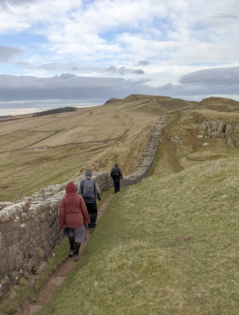
Strictly speaking, the conspicuous stony barrier we know as The Wall, is really the curtain wall, much reduced in height today – it was about 15 ft / 4.6 m when built.
The walkers path along the wall for the most part parallels it quite closely. This of course is the modern long-distance Hadrian’s Wall Path.
Behind it – to the south, and surviving quite clearly in places, is the Vallum – a ditch with earth banks on either side. (See below.)
To the north, there is archaeological evidence of further defensive features in places immediately in front of the curtain wall. These include ditches and also pits where the Romans placed wooden stakes, spikes or tree branches.

(Pictured) Evening sun on the vallum near High Shield reveals the now fairly shallow ditch and banks. This view looks south-west, with the wall out of picture, right.
As a reminder that there was a Roman presence before Hadrian was emperor, a Roman road later called the Stanegate (ie ‘stone road’) predates Hadrian’s Wall and ran in parallel with it. Some it it is traceable today.
In short, the whole area abounds in Roman remains, even if only about 10% of the main feature survives above ground today – mostly because the Roman stonework was too much of a temptation for farmers, builders, road makers and so on over the centuries.
But what is left is truly spectacular.
Walking Hadrian’s Wall

(Pictured) Looking down late in the afternoon on what has become known as ‘Sycamore Gap’ on Hadrian’s Wall. An Ice Age glacial meltwater channel through the crags now has a single tree growing in it (left in this pic.)
It has a kind of iconic status, thanks to its use as a film and tv location, most notably in ‘Robin Hood Prince of Thieves’.
Ah well, wait though, an update it’s sad to make: somebody cut the bloody tree down in 2023. Still, I suppose it was only a sycamore…not even a real native tree, they say. Still moronic though…
The images here centre on the Roman presence in the landscape to the west of Hexham in Northumberland, around the highest point of Hadrian’s Wall, 1131 ft / 345 m to the west of Steel Rigg. (The carpark there is popular and often busy as there is a fine viewpoint of The Wall.)
Note that while walking Hadrian’s Wall that England’s access laws are different to Scotland’s ‘Right to Roam’, where the emphasis is on an assumption you can pass through freely as long as there is no damage or disturbance (in a nutshell). A better description in Scotland is ‘Right of Responsible Access’.
England does have land designated ‘open access land’ where you need not stick to paths, otherwise your Ordnance Survey map will tell you where there are Rights of Way – paths that you are meant to stay on.
(This is why, if you are a Scot walking with English friends in England, they get a bit jumpy if you start suggesting short cuts across fields!)
It also explains why Ordnance Survey maps for England show Rights of Way, but they don’t show them on Scottish maps, where they are just ‘paths’. Incidentally, remember you can…
Buy OS Landranger maps direct from Ordnance Survey.Hadrian’s Wall seems to be a mix of open access land and rights of way, so access is easy and well signposted and there are plenty of helpful info boards.
English Heritage and the National Trust for England keep paths and stiles in pretty good order, with well-constructed stonework under foot where the going gets tough on the uphill stretches – of which there are quite a few while walking HAdrian’s Wall.
Sure, it’s muddy in places – it rains here quite a lot – but it all seemed safe enough to us, unless you are absolutely determined to peer over the edge of the north-facing whinstone sills – the rocky escarpments over which the walls climb.
A walk on this section of The Wall then is just an uphill-and-down-dale sojourn for as long as you feel your legs want to travel. In places the B6318 is reassuringly in sight to the south if you think you’re getting too far into the wilds!
Or, for that matter, too far from your accommodation. Hexham is a nice wee place. See hotel list here.
Booking.comWhy was Hadrian’s Wall built?
The coast to coast fortifications secured the north-west edge of the Roman Empire. Hadrian visited in 122AD and decided it was necessary ‘to separate the Romans from the barbarians’, according to Tacitus, his biographer.
But it wasn’t one long skirmish with those pesky northern tribes, often collectively called the Caledonians. The Wall was a frontier as well as a barrier and, like other frontiers, it had controlled crossing places.
People crossed for purposes of trade or marketing.

(Pictured) The Roman fort of Vindolanda pre-dates Hadrian. In this autumn image it is in the centre, middle distance, level with the signpost’s arrow. Hadrian’s Wall is on the horizon, right.
When was Hadrian’s Wall built?
There were plenty of events in Roman Britain before The Wall. Agricola had northern tribes such as the Selgovae (occupying today’s South of Scotland) under control by 80AD.
Roman roads stretched into what was later Scotland, linking major forts such as Trimontium near Melrose in today’s Scottish Borders.
Pictured (right or below) A Roman milestone on the Roman road that ran by Vindolanda. Note the ancient weathered signpost, courtesy of the Ministry of Works, a body almost as old as the Romans (OK, I exaggerate.)
Responsibility for monuments came into the hands of the Department of the Environment by 1977, (or earlier?) and in turn passed on to today’s English Heritage, or Historic Environment Scotland north of Hadrian’s Wall (by quite a bit).
An important and fascinating visitor attraction today, Vindolanda, was a Roman auxiliary fort on the line of the Stanegate – the road that existed before Hadrian’s Wall was built. If you’re walking Hadrian’s Wall, a visit her eis well worth the diversion.

However, it seems that the northerners refused to be cowed, even with the presence of the fort at Vindolanda, and others connected east-west by the Stanegate.
Some believe that in 117 AD, when Hadrian became emperor he had the idea to build something that would remind the northern folk of the might and resources of the Roman Empire. At least, that’s what some think – giving Hadrian a motive to build a huge wall.
Hadrian’s Wall – a statement of power
He gave orders for its construction to begin, probably before his visit to the north in 122AD. It took 15,000 men six years to build.
Some sources say 10,000 were involved, but whatever the accurate figure is, one feature of these builders is that they were all soldiers, trained as masons and engineers. The Wall was not built with slave labour.
It is possible, some historians think, that on completion the north-facing curtain wall was plastered and whitewashed. If so, it must then have been both unmissable and very threatening when viewed by any incoming war-band from the wilds of the north!
Walking Hadrian’s Wall Today

(Pictured) A small part of Aesica Roman Fort on The Wall at Great Chesters – and much less visited/interpreted than the more famous Housesteads Fort to the east.
Note how past and present overlap. The northern part of the fort is covered in farm buildings, much of the fort is in a grazing field.

In the same field, at Great Chesters, and among the more easily identified remains at the Aesica Fort, is a Roman altar. While walking Hadrian’s Wall, visitors have left coins (a variety of currencies) on it, presumably as an offering to Anorakus, the lesser-known deity associated with rambling.
Actually, it’s slightly spooky…
Anyway, after the Romans left, the gradual reduction of the wall began. You get the impression there isn’t an old church or farm building that doesn’t have some Roman stones built into it – likewise the farmers’ field dry-stane dykes. In places, these follow the course of Hadrian’s Wall and are built on the original foundations.

Bonnie Prince Charlie – what’s he got to do with it?
Bonnie Prince Charlie, too, had an accidental role in The Wall’s part-demolition. He passed south on his attempt to reach London, England, with his Jacobite Army in late 1745, then returned north after only reaching Derby.
An opposing (ie government) army based at Newcastle in the east could not travel west fast enough to cut him off.
Consequently, a military road (in the 18th-century, not Roman, sense) was built from Newcastle across England to Carlisle, to facilitate troop movement.
That road, today’s B6318, used copious amounts of stone from the nearby wall, which must have considerably reduced its height.

Today, the vallum, that is, the ditch and earth mounds, can be seen plainly as you drive this road – along with a variety of signposts to Roman points of interest. Meanwhile, The Wall itself is glimpsed a few minutes walk away on the craggy northern horizon.
Stretches of the Antonine Wall are in the care of English Heritage. England’s National Trust looks after six miles (9.6 km). The Northumberland National Park has a boundary just to the south of The Wall.
Is Walking Hadrian’s Wall worthwhile?
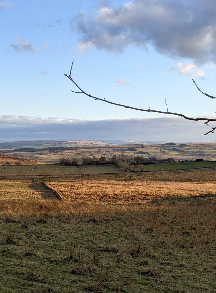
It’s one of the most atmospheric experiences you can have. Typical Northumberland landscape always has those sombre hills, curve beyond curve, disappearing into the hazy horizon.
Gaze northwards from the high sills beyond the wall-edge and imagine what it must have been like when what lay beyond was unknown to the soldier on guard and walking Hadrian’s Wall on patrol. The soldiers from North Africa, Syria, Hungary and other countries who made up the garrisons here must have felt the cold though!
In addition, remember it isn’t all just stepping out over field and crag. There are fascinating locations such as the fort at Housesteads and, just south of the wall, Vindolanda.
There you can get closer to the everyday life of the garrisons for both soldiers and their wives and children, as well as the local folk with whom they coexisted.

(Pictured) In just a few places, the footpath runs very close to some impressive drops over the scarp face of the Whinstone Sill, as here near the Crag Lough (Loch).
Perhaps the strongest sense you will have – paradoxically – is one of continuity. The stones originally cut by Roman masons survive in their reuse in sheep-fold and farm.
But it isn’t hard to imagine the wall at full height, complete with watchtowers. And the views, far out over the fells, haven’t really changed.
Is Hadrian’s Wall in Scotland or England?
The question of Hadrian’s Wall and whether it is in Scotland or England probably stems from the idea that Hadrian’s Wall was built to keep the ‘Scottish’ (really Caledonian) tribes out of the Romans’ Britannia province.
It isn’t in Scotland. That’s fairly obvious. In fact, (in Latin) the Vallum Aelium – Hadrian’s Wall – has never in its history been an England/Scotland border.
So, the references to Scots coming from ‘north of the Wall’ are mostly jocular. Probably…but wait…
A Roman Wall that was in Scotland
After Hadrian, the emperor Antoninus Pius expanded the Roman influence through the South of Scotland. The Antonine Wall was built on his orders across the 37 miles / 67 km between the Firths of Tay and Clyde on the narrow ‘waist’ of Scotland.
It was a turf wall with a substantial ditch, with forts and watchtowers and other Roman defensive measures. However, Antonius failed to bottle up the pesky northern folk so that his successor Marcus Aurelius gave up and held the line ‘down south’ once again on Hadrian’s Wall.
Not that that ended the Roman battle with the Caledonians: a later emperor, Septimus Severus, once again reoccupied it. His son Caracala made peace with the Caledonians and the occupiers once again went south, abandoning the Antonine Wall for good.
In conclusion, Hadrian’s Wall is easily to take in to any northward foray (I mean holiday/vacation) that heads for Scotland. You could include Berwick-upon-Tweed as well, before crossing into Scotland. I mean, take as long as you like in Northumberland. After all, it’s almost Scotland. It doesn’t feel like England to me!